01 / ACCESS
Try it with your own data.
The free version includes two projects and imports and exports of up to 1,000 features per layer. A single Meridian Pro purchase removes the limits and adds the advanced tools.
Meridian GIS brings spatial-data import, mapping, geometry editing, analysis, and reporting into one native workspace. Work with GeoJSON, KML, CSV and projected data, build repeatable workflows, record GPS tracks, and export finished deliverables on your device.
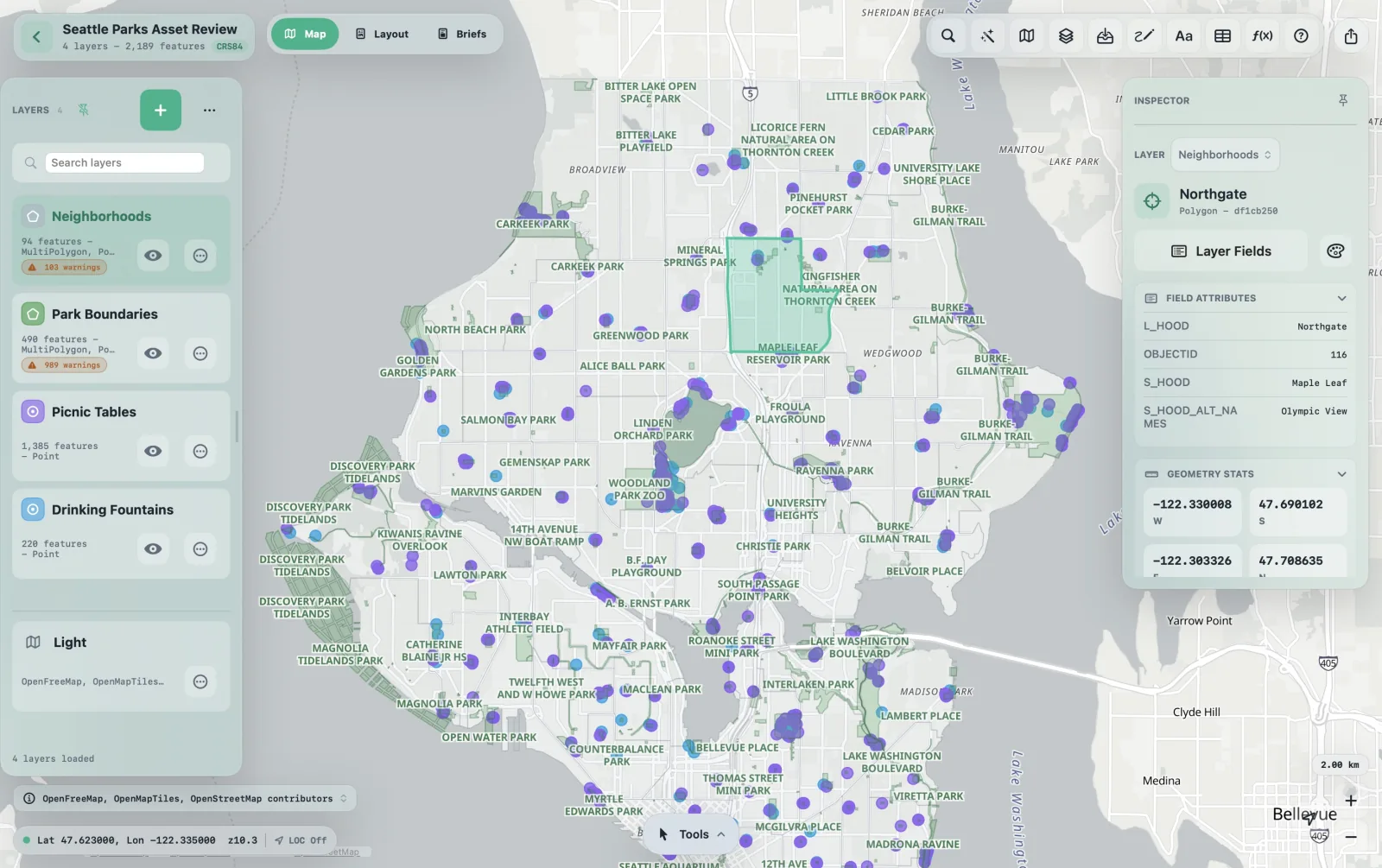
Meridian keeps the map in view while tools, tables, and inspectors stay close at hand. Version 1.1 expands data support, repeatable workflows, and reporting without weighing down the workspace.
Each .gispad project lives on your device. Share or sync it when your work calls for it.
Declare source CRS, transform projected imports, convert coordinates, and export GeoPackage or CSV/WKT in the target CRS you choose.
SwiftUI on Apple platforms, MapLibre canvas, and a Rust geospatial core. Heavy import, analysis, and export work stays off the main thread.
Import, edit, validate, analyze, style, chart, report, and export without leaving the project or sending data to a service.
Version 1.1 is Meridian's largest release so far, and the app is now free to download with a one-time Pro upgrade. Save analysis chains as workflows, keep reports inside a project, capture tracks and photos in the field, and carry projected data from import through export.
The free version includes two projects and imports and exports of up to 1,000 features per layer. A single Meridian Pro purchase removes the limits and adds the advanced tools.
The Workflow Builder wires analysis tools into a visual graph with typed ports, runs the whole chain with per-node progress, and saves into the project so you can run it again next month.
Map Briefs are saved, multi-page PDF documents with six page types: cover, map focus, narrative, chart, notes handoff, and summary. A review step catches missing or misleading content before export.
Record GPS tracks on iPad with an accuracy filter and honest pause on leaving the app, import geotagged photos as points, and attach photos and files to features inside the project package.
Declare a layer's CRS, reproject with the Project tool, transform projected imports to editable WGS84, convert coordinates in Go To, and export GeoPackage or CSV/WKT to a chosen target CRS.
GeoPackage, KML/KMZ, Shapefile, File Geodatabase, live OGC/WFS/ArcGIS services, point clustering, eight chart types, and a fully guided PDF map layout with bookmark packets.
Meridian 1.1 keeps import, editing, analysis, styling, and reporting in a map-first workspace. Bring in source data, track CRS and validation, then finish with clean exports, a map layout, or a saved brief.
Every workspace is a local .gispad project on your device. Import GeoJSON, GeoPackage, Shapefile, KML/KMZ, CSV with X/Y, WKT, or WKP, PMTiles basemaps, and read-only File Geodatabase feature classes. Connected imports cover OGC API Features, WFS, and ArcGIS Feature Services, with refresh provenance kept out of clean exports.

Meridian can declare a layer's source CRS, transform projected imports into editable WGS84 storage, show per-layer CRS status, convert typed coordinates, and guide you through common source/working/output CRS decisions. Export GeoPackage and CSV/WKT in the target CRS your handoff needs.


Draw points, lines, polygons, rectangles, and multipolygons. Move, add, and delete vertices directly; split a line or merge compatible features. Snapping is on by default, and it snaps to your exact stored geometry, not a simplified render. In the field, capture a point from device GPS, add a raw GPS vertex while drawing, or record a whole track that becomes an ordinary line feature.
Area and perimeter are calculated geodesically on the ellipsoid. Analysis tools use exact GeoRust predicates and show progress, cancellation controls, limits, and accuracy notes. Results return as standard layers, ready to style, label, inspect, chart, and export.


A virtualized attribute table stays fast at thousands of features. Search, sort, filter, and keep selection linked to the map. Type-aware fields, conversion previews, schema-aware forms, field calculation, and chart exports keep tables useful beyond inspection.
Multiple layers per project, each with visibility, order, lock, opacity, style, labels, filters, and metadata. Symbolize with a single symbol, by category, or graduated by a numeric field. Marker shapes, a cluster mode that groups dense points into counted circles, definition filters with live counts, label controls, and PMTiles basemaps let a working map become a presentation map without leaving the project.


Add tools from a searchable palette, wire an output port to a compatible input, and configure each node in its inspector. Ports are typed, so incompatible or circular connections are refused with a reason rather than a bad result. Run executes in dependency order with per-node progress.
In-between outputs stay hidden working layers and are cleaned up when the run ends, unless you keep them. If a node fails, finished upstream work is kept so the run can continue from where it stopped. Saved workflows live in the project package and travel with it.
Briefs sits beside Map and Layout as a third workspace tab. A layout is a working single page; a brief is a saved document stored inside the project package, so it travels with every shared or duplicated copy. Choose from six page types: cover, map focus, map narrative, map with chart, notes handoff, and summary. Each map page can use a saved bookmark and its own layer selection.
A review step blocks export on hard problems such as a missing title or unresolved references, and warns about dirty layers, active filters, CRS warnings, and hidden layer scopes, so a printed brief cannot quietly mislead. Export to multi-page PDF with a preview first.

Type what you want, such as "properties within 400 m walk of this school" or "export selected schools to CSV with WKT." Meridian matches the request to existing tools and opens the right surface with layers, scope, and units prefilled.

Meridian covers a GIS project from first import to final handoff. The tools are built in, operations can be reviewed, and project data stays local by default.
GeoJSON, GeoPackage, Shapefile, KML/KMZ, CSV spatial tables, PMTiles, and read-only File Geodatabase, each with preflight and clear warnings.
Natural Earth, OSM/Geofabrik, US Census, Data Commons tables, GeoNames, OGC API Features, WFS, and ArcGIS Feature Services.
Source CRS definition, working CRS display, coordinate conversion, CRS guide, import transforms, and target-CRS export where formats support it.
Chain analysis tools into a saved, repeatable graph with typed ports, per-node progress, hidden intermediates, and resume after a failed step.
Saved multi-page PDF reports built from cover, map, narrative, chart, notes, and summary pages, reviewed for missing or risky content before export.
Single, category, graduated, custom marker shapes, point clustering, opacity, labels, zoom ranges, and definition filters with live match counts.
Create or update typed fields, preview before/after samples, calculate geometry values, arithmetic, constants, copied fields, and text.
Bar, histogram, pie, line, scatter, box plot, density, and matrix heatmap charts, with selection linking and PNG/JPG/PDF/SVG export.
Join CSV, imported tables, Data Commons statistics, or another layer by key fields, with deterministic prefixes and typed outputs.
Text notes, arrows, callouts, circles, rectangles, freehand sketches, and per-note styling, kept separate from authoritative analysis.
Docked Measure readout, foreground-only location, accuracy circle, Capture Point, Add GPS Vertex, and track recording that pauses when you leave the app.
Import geotagged photos as points, and attach photos or files to features. Attachments live in the package and never leak into exported GIS data.
Search features, look up places by name, save and update map views, jump to typed or pasted coordinates, and convert CRS on the way.
Geometry, schema, CRS, privacy, and export checks run before risky handoff. Project Health shows what needs attention.
Clean GeoJSON, GeoPackage, Shapefile zip, styled KML/KMZ, and CSV + WKT/WKP. Internal edit IDs are never written out.
Guided PDF layouts with presets, full-bleed maps, graticule, legend, scale bar, north arrow, dynamic text, and bookmark packets.
Project thumbnails and downloadable samples, each with an example brief, give you a useful starting point before you open your own data.
Hand off the whole .gispad package through an Export Inspector that lists what's included, attribution owed, and anything blocking a clean share.
Start free with your own projects and data. One Meridian Pro purchase removes the limits and adds analysis, automation, charts, layouts, and Map Briefs to your Apple Account.
Enough to evaluate Meridian against your own data, in your own CRS.
An early price for version 1.1. One purchase covers Mac and iPad on your Apple Account.
Everything in Free, plus
Meridian Pro is a single non-consumable purchase at your local App Store price. It is tied to your Apple Account, so it covers your Mac and iPad and can be restored after a reinstall. Free-tier limits apply to projects you create. Shared .gispad packages and sample projects always open in full.
Imports record source CRS provenance, transformed layers show status, and target-CRS exports require an explicit choice where supported.
Area, perimeter, length, buffer warnings, and density notes are based on geodesic WGS84 routines rather than screen projection shortcuts.
GeoJSON, GeoPackage, Shapefile, KML/KMZ, and CSV/WKT export committed data without internal edit IDs, scratch rows, or session state.
Projects are local by default and the app works without a Meridian account. You choose whether to use iCloud Drive, online basemaps, or connected data sources.
Location runs only while Meridian is in the foreground. GPS tracks pause when you leave the app, and discarded recordings are not saved.
Meridian reads only the images you select in the system picker. Attachments stay inside the project package and are excluded from exported GeoJSON, GeoPackage, Shapefile, KML, and CSV. Before you share, the Export Inspector lists their count and size.
Pointer and trackpad drawing, keyboard shortcuts, large tables, layout and brief work, and big-screen analysis. A true native macOS app.
Apple Pencil and touch editing, GPS capture and track recording, snapping, analysis, layout, and reviewable export. The field platform.
A native desktop peer of the Mac app, using the same Rust engine and .gispad projects, with Mica chrome and dockable panes. Field GPS stays on iPad.
A scoped field companion: open projects from iCloud Drive or Files, edit attributes, drop notes, measure, switch basemaps, and resolve conflicts. See what it does ↓
The Meridian companion for iPhone opens the same projects you authored on iPad or Mac, from iCloud Drive or Files, so you can read your map in context, make quick corrections, measure, and drop notes one-handed. It is intentionally scoped for field review, not a crowded miniature desktop.


Download Meridian free and work with your own data. Upgrade to Pro with one purchase when you need the larger limits and advanced tools. The same iOS app includes the iPhone companion for field review.
Free to download · Meridian Pro your local App Store price · one purchase